During our Reef Check activities in june 2015, our friend Ahmed M. Shawky, marine biologist, ranger and environmental researcher of the Wadi El Gemal National Park, made a guided tour with us through his national park.
It was a fantastic trip and Ahmed took us to some really unique places we had never seen before…
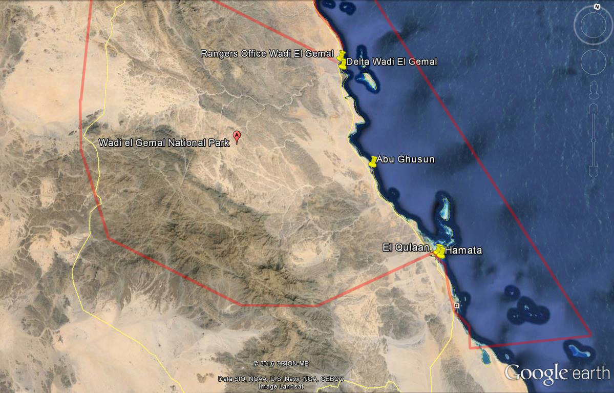
We went by bus and stopped at three certain places along the coast line. Our first stop was at “Delta Wadi El Gemal”, quite near beside the rangers office at the northern entrance of this protected area, 52 km south of Marsa Alam.
Here, in the “desert”, we were surprised by rich vegetation, facilitated by the ground water along the “Wadi” (dry riverbed), including Doum Palms (Hyphaene sp.). and a really huge, old tamarisk tree (Tamarix sp.), which is specialized to grow on saline soils.
We discovered a fresh water pond, surrounded by Common reed (Phragmites australis) and other abundant vegetation. Ahmed told us that this is an important drinking place for mammals like camels and Gazelle, birds and other animals in the area and he explained the characteristics of the area:
In 2003 the Wadi El Gemal area was declared as egypt´s 24th national park up to that date, comprising an area of 4770 km² of land and 2000 km² of marine waters and with a 67 km coastline. The high Red Sea mountains in the hinterlands divide the watersheds of Wadis flowing eastward to the Red Sea and those draining westward into the Nile valley. The highest mountain within the park is the Gebel Hamata with 1975 m. The park is habitat for the rare Dorcas Gazelle (Gazella dorcas) or the Nubian Ibex (Capra ibex nubiana) which mainly live in the mountains. Wadi El Gemal is the third largest Wadi in the eastern desert and one of the better-vegetated Wadis with an estimated watershed area of around 1500 km². But the park encompasses also more than 40 other Wadis, besides Wadi El Gemal, the biggest ones are Wadi Abu Ghusun, Wadi al-Ranga and Wadi al Readaa. They all together form a system of drainage basins which collect runoff water. There are five islands in the park, Wadi El Gemal Island at the north end of the park and the Qul´an archipelago, the so-called “Hamata Islands” (Siyal, Shawarit, Umm al-Sheikh and Mahabis Island) north of Hamata.
The climate is hyper-arid with hot and rainless summers and mild winters. It does not rain every year, most precipitation occurs only briefly and locally, often as heavy downpours that cause flash flooding. The last flood at Wadi El Gemal was in November 2004 after ten rainless years. The roughly 50 to 100m wide fringing reef along the coast is only interrupted at the mouths of some larger Wadis, called “Marsa” (natural bay), as a result of the rare, periodic torrential floods.
Along the coast line, especially in the southern part of the national park, there are various more or less extensive occurences of mangroves, formed by the White Mangrove (Avicennia marina), which is the only mangrove species in the area. So our next stop was the mangroves of El Readaa. The White Mangrove has aerial roots pneumatophores); which allow the plant to absorb oxygen, which is missing in the muddy sediment. Under favourable conditions where both, fresh and saltwater are present, the white mangrove can grow up to 14 m height, whereas under high saline conditions it may experience a stunted growth. The species can tolerate high salinity by excreting salt through its leaves. The mangroves play an essential role within the whole coastal ecosystem. They are not only an important place for reproduction and offspring of marine animals, habitat for numerous specialized organisms, many species of birds, they are also important to connect the nutrient cycles. Mangrove crabs munch on the mangrove leaves, adding nutrients to the muds for other bottom feeders. Beneath the mangroves we also notice plastic waste, one of the human impacts of the modern age… We also see the “Sabkha” (salt flat) of El Readaa. Salt flats are formed along arid coastlines and are characterized by evaporite-carbonate deposits: any trapped water evaporates and leaves a flat salt pan back, or sabkha.
Our third and last stop is El Qulaan Village, near of Hamata at the southern end of the park. Here we were friendly invited to a nice cup of traditional eastern desert coffee, called “Al Ga’bana”. Ababda and Bisharia tribes in the Southern Red Sea have made their coffee time into an elegant presentation and a festive highlight of the day. Over a hearth water is boiled with green coffee and various spices. The utensils used to make this drink, for example a specially designed container named “Kabota”, is a traditional kit in every household.
To get another coffee, you only have to turn your cup. We were told that one either has to drink one, three, five, …seven…Gabana – an even number is not allowed! But after just one Gabana we feel the strong stimulating effect…
Shortly before sunset, we climb on a hill near the village to watch the sunset over the reefs and mangroves of Wadi El Gemal nationalpark. What a lovely trip! We would like to thank our friend Ahmed for this unforgettable experience!
See ya soon again!
Text and photos © Stephan Moldzio (2015)
